District E
Lake Houston Safety Plan
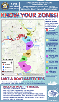
 The purpose of the Lake Houston Safety Plan is to provide both Lake Houston residents and visiting recreational users with information that will prepare them to better identify their location on the lake and how to best report an incident to 9-1-1. The map was created through collaboration with the Houston Fire Department, Houston Police Department, Houston Planning Department, Houston Office of Emergency Management, Houston Emergency Center, and the Houston Public Works Department. This safety plan launched April 1, 2021.
Mayor Pro Tem Dave Martin is proud this safety plan is already making a positive impact, in early April 2021 a caller reported a kayaker in trouble on the Lake and knew they were located in the Orange zone. First responders reached the kayaker in trouble, wearing a life jacket, pulling them and their boat out of the lake within twenty minutes.
The District E Office is actively working with communities on the lake to distribute this information. Please use the resources below to print your own maps, share with neighbors, and #knowyourzone.
Should you like to request a presentation for your group (HOA, Civic Club etc.) or receive resources directly please email the District E Office at districte@houstontx.gov.
- Lake Houston Zone Map (.pdf)
- Lake Houston Zone Map (.png, small)
- Lake Houston Zone Map (.png, large)
- Lake and Boat Safety Tips with Map (.pdf)
- Safety Tips (.pdf)
- Blue Zone Information Sheet (.png) | Blue Zone Information Sheet (.pdf)
- Green Zone Information Sheet (.png) | Green Zone Information Sheet (.pdf)
- Orange Zone Information Sheet (.png) | Orange Zone Information Sheet (.pdf)
- Pink Zone Information Sheet (.png) | Pink Zone Information Sheet (.pdf)
- Purple Zone Information Sheet (.png) | Purple Zone Information Sheet (.pdf)
- Red Zone Information Sheet (.png) | Red Zone Information Sheet (.pdf)
- Yellow Zone Information Sheet (.png) | Yellow Zone Information Sheet (.pdf)


