|
Implementation Approach
The City of Houston is entering Phase III of its Urban Corridor Planning (UCP) initiative. We have received input from the consultant team, citizens, businesses, property owners, and the real estate and development community. No actual rules or ordinances have been written, but the City is moving forward in turning concept into policy. The City will continue to dialogue with all respective interests as these details become more fully developed.
Lessons Learned
Throughout this project, we concentrated on what is needed to enable and encourage pedestrian mobility in our urban environment. Two areas of focus emerged:
1) Ensure that a sufficiently wide and appropriately designed public space is available along streets for pedestrians to safely and comfortably walk. This public area for pedestrians is termed the “pedestrian realm.”
2) The adjacent development also affects pedestrians. How buildings are designed and where they sit on their lot can have a significant impact on the ease and comfort with which pedestrians access them from the sidewalk or walk past them down the street.
1. Pedestrian Realm Cross-section
Our UCP consultant team produced a recommended design standard for the pedestrian realm that differs substantially from the existing City standard (a 4-foot sidewalk). To ensure consistency over time as development and redevelopment occur, the pedestrian realm should be measured from the curb, rather than from the public right-of-way, which tends to be inconsistent from location to location. This cross section and plan view show key elements of this standard:
1) A total width of 15 feet from the final alignment of the back of the curb.
2) The first 10 feet adjacent to the curb will accommodate street trees, above-ground and below-ground utilities, and landscape amenities such as benches, water fountains and waste receptacles. Street trees are important both for shade and as a safety barrier.
3) The 5 feet along the outer (private) edge of the pedestrian realm is the “zone” shown in the diagram below– the main sidewalk – which is always kept free of obstacles to accommodate pedestrian through traffic and adjacent property access.

The pedestrian realm, in many locations, will be larger than the existing public right of way behind the curb. Any additional public area behind the property line will require an easement from the property owner upon development or redevelopment. This easement would be required when the development or redevelopment occurs.
2. Buildings' Relationship to The Sidewalk
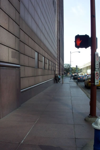
Examples of development that discourage pedestrian mobility
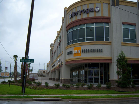
Sidewalk design is important, but other aspects of the built environment have a strong impact as well. Houston has many examples of development that discourages pedestrian mobility: tall, long blank walls along sidewalks, landscape barriers between the sidewalk and building, and automobile-oriented development that places surface parking lots in front of buildings and creates discontinuity in the pedestrian environment. The following photos illustrate these issues. To address these impacts, the City is considering other elements for inclusion in the rules and regulations.
 |
Blank Walls |
Automobile-oriented design that creates discontinuity
|
Landscape barriers
|
Elements Under Consideration
Regarding the relationship of buildings to the pedestrian realm, the following elements are being considered:
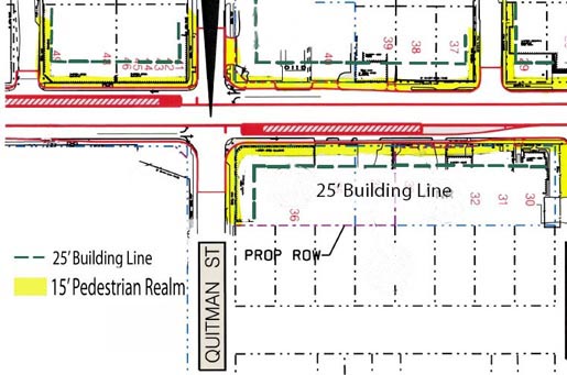
- The Build-within-zone would be the distance adjacent to the edge of the pedestrian realm where the front of the building is located. This is to have buildings built close to the sidewalk to minimize the distance that pedestrians must travel to access them. Since vehicle parking and circulation will not be allowed in this space, it enhances safety by minimizing pedestrian-vehicle conflicts.
- Minimum built frontage means the minimum share of the lot frontage along the street (and pedestrian realm) that should be occupied by the front of the building. This provides a more comfortable environment for pedestrians by giving a sense of enclosure (versus a sidewalk abutting a parking lot) and provides direct access from the sidewalk to buildings with multiple entrances (such as a multi-tenant retail center).
- Minimum transparency defines the share of the building facade that should be covered by doors, windows, soft landscaping, etc. to avoid long stretches of blank walls along the pedestrian realm.
- Sidewalk entrances should be available to all properties – pedestrians should not have to travel to the back side of the building to enter, and entrances should have a maximum distance from the sidewalk if they are located on the side of the building.
- Driveway spacing is vital because driveways break up the pedestrian realm, eliminate shade, and increase vehicle-pedestrian conflicts. While no property will be denied access from the adjacent street if that is their only option, driveway access would be encouraged from side or rear streets and large properties will have a minimum spacing standard between multiple driveways.
Elements Under Consideration (See Flash illustration)
Issues to Consider
Several other questions arise in the development of Urban Corridor rules and regulations.
(1) Mandatory vs. Incentives - should the desired standards be mandatory for new development, incentive-based optional standards, or a combination?
(2) Geographic application - should the application of standards be different in different parts of the corridors?
(3) Neighborhood protection - can neighborhood protection measures be incorporated so that the City is not encouraging the densification of stable neighborhoods?
1. Mandatory vs. Incentive
The City recommends using a mandatory approach with the pedestrian realm, because it is essential to pedestrian mobility. A mandatory approach assures a consistent sidewalk environment over time as development occurs. A new standard should be applied to certain streets in the corridors that require the expanded sidewalk. In addition, a mandatory driveway spacing standard for properties with longer frontages should be applied to the same streets. The other physical elements (such as the build-within-zone, minimum built frontage, etc.), though highly desirable, are considered items that may be more appropriate for an incentive-based approach.
Economic / Market Implications
There are economic and market implications for applying new design standards to buildings in the corridors. First, there is concern over whether this might cause an increase in direct construction costs for properties subject to the standards. The second issue is that the design standards, if mandatory, could place properties at a competitive disadvantage with new development that is not subject to those standards. For example, a property where off-street parking is not allowed in front of a new building may lose potential tenants to a nearby property where such a parking arrangement is allowed. Our Stakeholders developed a term for this: the “1,321 effect,” meaning the first point just outside the ¼ mile distance (1,320 feet) from a light rail station, assuming that Urban Corridor standards would be required inside the ¼ mile distance. It is important that the proposed rules and ordinances are not disincentives.
Opportunities for Incentives
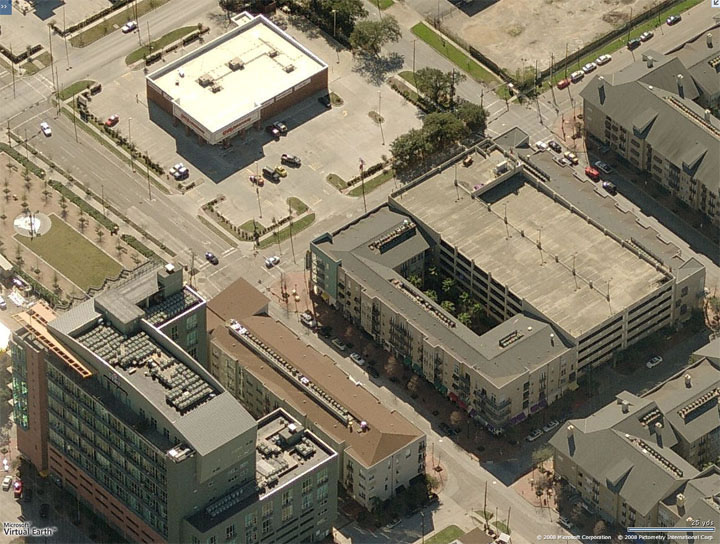
How could an alternative incentive-based approach work? A set of Urban Corridor standards would be applied to new development on an incentive basis. Certain existing regulations would be relaxed, providing a benefit to the development project, if it meets these design standards. The benefits with the most potential appeal would be increasing the buildable area on a lot and reducing on-site parking requirements. However, developers could still choose to build under the existing regulations and not be eligible to receive these benefits.
This illustration shows that many properties could achieve a significant opportunity to increase their buildable area if the developer chooses to adhere to Urban Corridor standards. Note the white space between the current required setback of 25 feet from the property line and the area would be required for the pedestrian realm (15 feet behind the curb). That remaining white space represents additional buildable area that was not available under existing setback requirements.
2. Geographic application
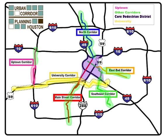
It became clear that new rules and regulations couldn't take a “one size fits all” approach. Conditions differed too much among the various neighborhoods and districts covered by the corridors. Therefore, three different and distinct application areas have been identified:
- The “Uptown” core area, mainly the area west of IH 610 along Post Oak Boulevard, has dense mixed-use development, many tall buildings, a large amount of new development and redevelopment, and light rail stations that are planned to be close together.
- The “Other Corridor” areas feature low to moderate density development and mostly low-rise buildings, including many single family detached homes in established neighborhoods, little or no new development in many areas, and light rail stations that are generally further apart.
- The “Core Pedestrian District” covering Downtown, Midtown, and East Downtown has small block sizes, both high density and low density mixed-use development, both high-rise and low-rise buildings, minimal established residential neighborhoods, rapid redevelopment, and multiple light rail lines. Note that the Core Pedestrian District covers an area not strictly confined to a narrow band along the light rail lines.
Until the University Corridor work has been fully completed, the City is holding off designating application areas in the corridor.
The principal differences among the way rules and ordinances would be applied among the different districts is the voluntary, incentive-based approach for certain desired elements versus requiring the elements via mandatory standards. (The pedestrian realm standards and driveway spacing would be mandatory everywhere.)
Uptown: Pedestrian-oriented building design elements would be encouraged through voluntary, incentive-based standards throughout the Uptown application area. Developments could also be built to the current rules (existing parking and setback requirements) that create a more automobile-oriented design.
Other Corridor: Pedestrian-oriented building design elements would be encouraged through voluntary, incentive-based standards, tied to neighborhood protection standards. These rules would apply within a ¼-mile distance of a light rail station. Developments could also be built to the current rules (existing parking and setback requirements) that create a more automobile-oriented design.
Core Pedestrian District: Some of the pedestrian-oriented building design elements may be required through mandatory standards, with benefits (the same as those granted by incentives in other application areas) automatically offered in return. It is possible that additional voluntary design standards may be applied with another set of incentives.
3. Neighborhood protection
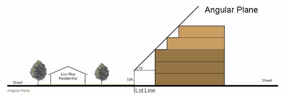
In the Other Corridor areas, a potential method of neighborhood protection for neighborhoods of stable/single family detached homes is to apply an angular plane standard as diagrammed. This would limit the height of a building on the sides of the property adjacent to stable single family detached areas. The angular plane would only apply where a property owners wishes to obtain incentives such as reduced onsite parking requirements and reduced setbacks.
Some of the ¼-mile distance areas around light rail stations may be dominated by stable neighborhoods of single family detached homes. The City may consider developing a measurement of the single family detached presence in these areas. If the measurement exceeds certain thresholds, then the incentives that are associated with pedestrian-oriented design in other locations may not be made available.
Upcoming Process
Much work remains. The actual rules and ordinances in the corridors must be drafted. Public participation and comments will be included as well as discussion with the Urban Corridor Stakeholder Committee, the corridor communities, and the real estate and development community. Then a review and approval process will include the following bodies:
- The Mixed-Use / Transit-Oriented Development Committee of the Planning Commission
- Planning Commission
- The City Council Committee on Regulation, Neighborhood Protection and Development
- City Council
Citizen participation is encouraged at all levels from the Planning Commission committee to City Council.
Urban Corridors Study Phase II and III Consultant Report
|